Monitoring of Terrestrial habitats by Integrating Vegetation Archive Time series in Europe
Call
Duration
01/04/2024 – 31/03/2027 (provisional)
Total grant
Approx. 1,4 mil. €
More information
Ute JANDT
ute.jandt@botanik.uni-halle.de
Partners of the project
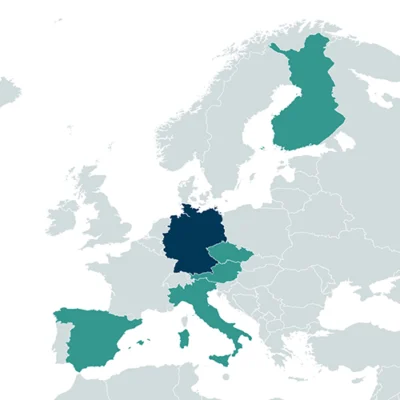
- Faculty of Natural Sciences I, Institute of Biology / Geobotany and Botanical Garden, Martin Luther University Halle-Wittenberg, Halle, Germany
- University of Rostock, Rostock, Germany
- Department of Botany and Biodiversity Research, University of Vienna, Vienna, Austria
- Biodiversity Research Institute (IMIB), University of Oviedo, Mieres, Spain
- Department of Biological, Geological and Environmental Sciences, Alma Mater Studiorum – University of Bologna, Bologna, Italy
- Department of Sciences, Roma Tre University, Rome, Italy
- Faculty of Science / Department of Botany and Zoology, Masaryk University, Brno, Czech Republic
- Faculty of Humanities, University of Oulu, Oulu, Finland

Context
Reversing the biodiversity crisis requires precise quantification of the spatial patterns and temporal trends of biodiversity loss, as well as knowledge of links to the main drivers of global change. Monitoring the trajectory of biodiversity is therefore a cornerstone of EU environmental legislation. However, assessments are not yet well harmonised across countries. MOTIVATE aims at improving the characterisation and reporting on the state and trends of European terrestrial habitats and plant biodiversity, in order to provide a deeper understanding of the pressures and drivers underlying biodiversity changes in Europe.
Main objectives
MOTIVATE will substantially improve the quality of reporting on the conservation status of the EU’s terrestrial habitats, by combining so-far untapped data with remote sensing, modelling and extrapolation methods. This will improve the standardisation of reporting and support national conservation agencies and decision-makers.
Main activities
MOTIVATE will integrate expertise and techniques from different knowledge domains, namely vegetation science, biodiversity modelling, remote sensing and human geography. At its core is the community-owned database of vegetation plot time series ReSurveyEurope, integrating on-the-ground data with ongoing monitoring under the Habitats Directive. These data will be used to produce both habitat- and species-specific assessments of plant biodiversity status and trends, and to develop workflows for upscaling these results using remote sensing, and for attributing drivers to the observed changes based on biodiversity modelling. In addition, MOTIVATE will establish pipelines to collect additional vegetation-plot time series in the future, and invest in capacity-building to secure the involvement of future generations in the continued sampling of time-series. Knowledge exchange among multiple stakeholders will help understanding how biodiversity data can be integrated with broader public perceptions. This will improve how monitoring data is put into practice by decision-makers.


