“Updated roadmap for novel monitoring technologies”
Published: October 2026 | DOI: 10.5281/zenodo.23387893
This report assesses the deployment of novel technologies for biodiversity monitoring among Biodiversa+ partners and sets out recommendations to support their routine use at national and transnational scales. It builds on the first assessment published in 2024, drawing on a wider partner survey and expert discussions held during the Biodiversa+ Science Fair in Barcelona in May 2025. It covers six technology groups: bioacoustics, camera traps, environmental DNA (eDNA) & genomics, sensor networks, UAVs & drones, and remote sensing.
Key findings
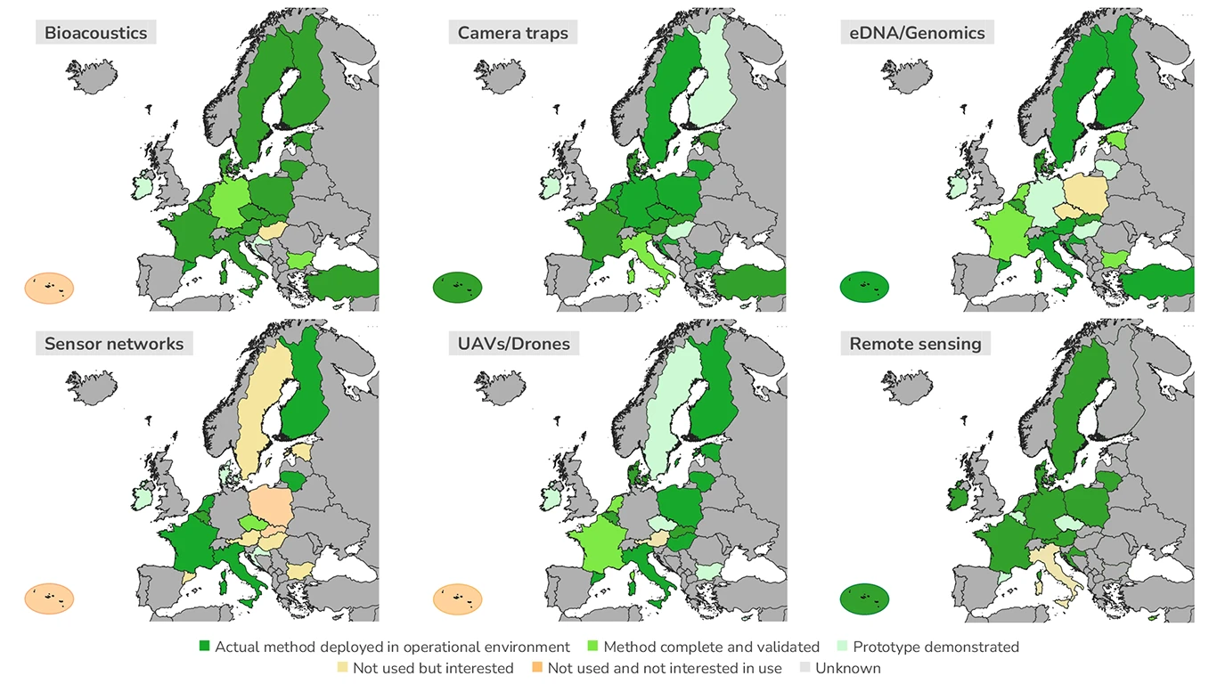
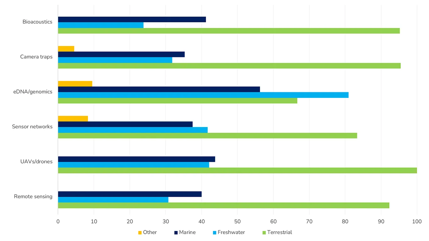
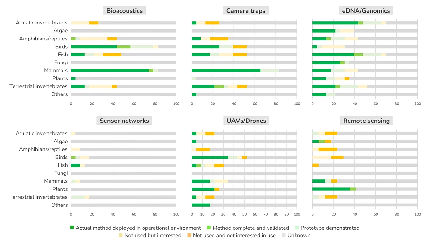
- Deployment remains uneven across technologies, species groups and environments. Some applications are already operational, particularly for birds and mammals, while others remain at an early stage. All six technology groups are fully deployed in the field by at least one responding partner, showing that expertise is available within the partnership.
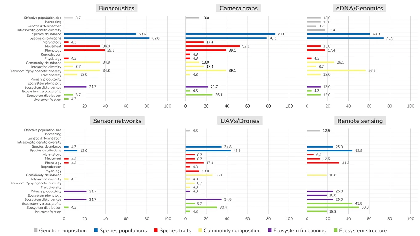
- Species and communities receive more attention than ecosystem features. Remote sensing and sensor networks offer particular potential for monitoring ecosystem structure and functioning, while eDNA and genomics could help fill gaps for less-studied species groups.
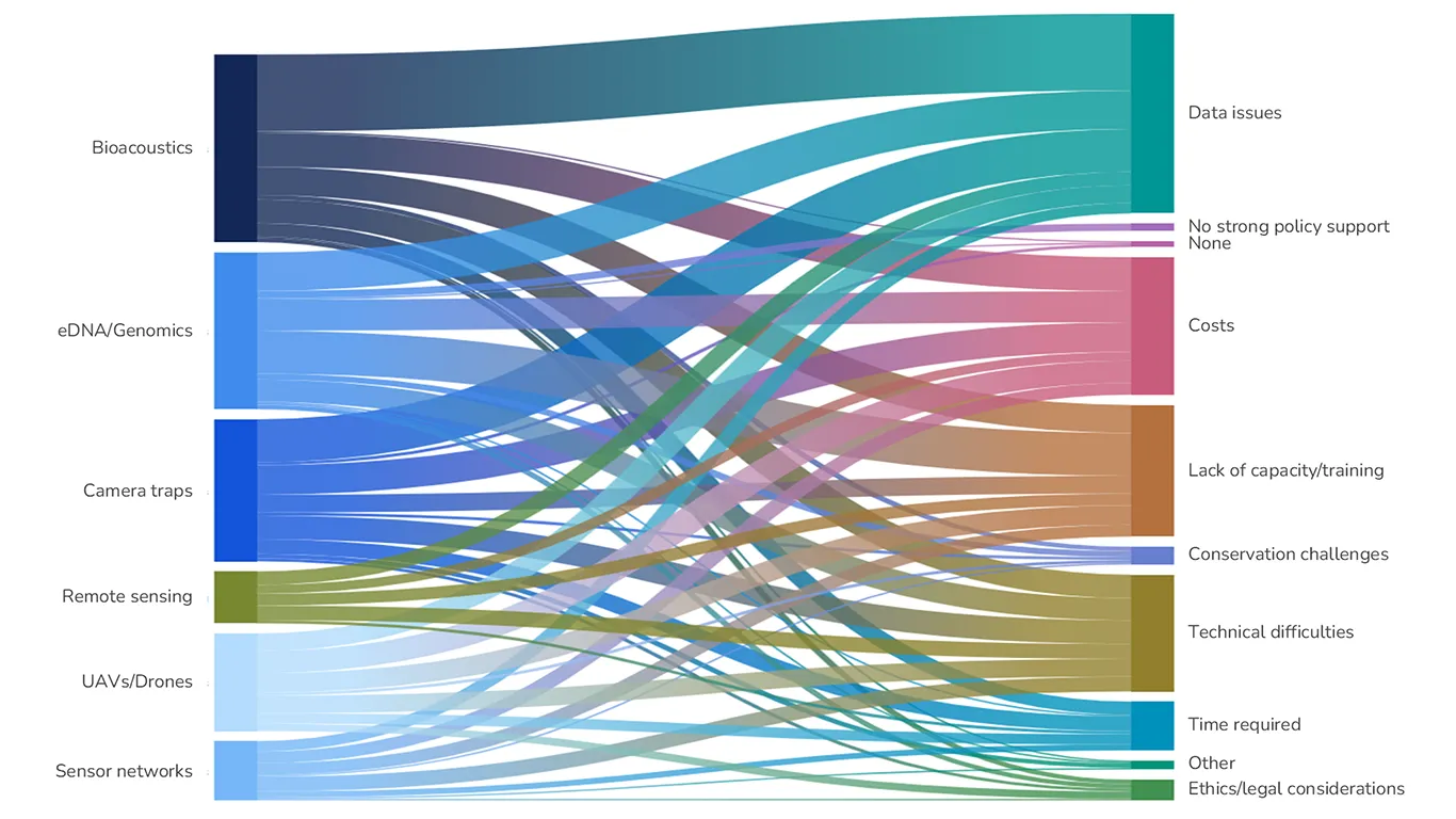
- Wider uptake depends on more than technological development. Shared challenges include data management and storage, limited expertise and funding, insufficient standardisation, and gaps in reference databases.
- New technologies need to complement existing monitoring. Their integration must preserve long-term biodiversity records and produce reliable information that meets policy needs.
Findings by technology
Bioacoustics is most widely deployed for mammals and birds, particularly to monitor species distributions and abundance. Applications for other groups, including fish and terrestrial invertebrates, remain less developed. Managing the resulting recordings is a major challenge: partners report difficulties with data analysis, storage and integration, alongside costs and limited technical capacity. Shared processing tools, reliable sound reference libraries and training could support wider use.
Camera traps have the broadest operational deployment among the surveyed technologies. They are used mainly for mammals, followed by birds and terrestrial invertebrates, with more limited deployment for aquatic species and amphibians and reptiles. Data storage and integration remain important constraints, and partners report difficulties automating species identification. Many want to expand their use of machine learning for image analysis, highlighting the need for suitable software, reference datasets and technical support.
eDNA and genomic methods are being used across all species groups covered by the survey, with particularly strong uptake in freshwater environments. They offer opportunities to monitor less-studied groups and fill gaps in knowledge about species and communities. Wider implementation is constrained by limited training, incomplete reference databases, difficulties comparing results and costs. Harmonised methods, better reference libraries and international collaboration are priorities for routine use.
Sensor networks have the lowest deployment among the six technology groups, although several partners express interest in adopting them. Reported applications largely measure environmental conditions, such as temperature and soil or water parameters, which can support understanding of ecosystem functioning. Technical difficulties, costs and limited expertise are the main barriers. Sharing practical experience and strengthening technical capacity could help partners develop and implement these approaches.
Drones are used to monitor birds, plants and mammals, as well as habitats and ecosystem features. Reported applications include photography, video, multispectral imagery and LiDAR, providing information on species distributions, habitat structure and disturbances. Costs are the most frequently reported constraint, alongside training needs, technical difficulties and data management. Wider implementation would benefit from shared protocols and support for processing and integrating drone-derived data into monitoring programmes.
Remote sensing, added in the 2026 survey update, is used particularly for vegetation and ecosystem structure, including ecosystem distribution and vertical profiles. Partners report using satellite imagery, airborne observations and LiDAR, as well as products from services such as Copernicus. Technical difficulties, data storage and integration, and limited expertise constrain wider uptake. Harmonised workflows and stronger connections with field monitoring could help translate these observations into reliable biodiversity information.
Priorities for routine implementation
The roadmap sets out seven strategic recommendations:
- Strengthen coordination across monitoring communities to develop common standards and protocols, share expertise and avoid duplication.
- Foster collaboration with the private sector, including opportunities for joint technology development and complementary funding.
- Support shared data infrastructure for storage, analysis and exchange, following FAIR principles so that data are findable, accessible, interoperable and reusable.
- Bring in additional expertise in engineering, data management, software development and artificial intelligence, alongside essential biological and ecological knowledge.
- Invest in reliable, accessible reference databases to support DNA-based identification and the training and validation of sound and image recognition tools.
- Develop integration plans that connect new technologies with established monitoring methods and maintain the continuity of long-term observations.
- Align monitoring initiatives with national and international programmes and policy requirements, helping results contribute to wider assessments and reporting.
The roadmap will guide Biodiversa+ work on novel monitoring technologies, including capacity building, knowledge exchange and collaboration to support more harmonised biodiversity monitoring across Europe.